


Voting Districts not defined, Lincoln County, Maine
About
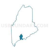
Outline

Summary
| Unique Area Identifier | 591587 |
| Name | Voting Districts not defined |
| County | Lincoln County |
| State | Maine |
| Area (square miles) | 116.01 |
| Land Area (square miles) | 0.00 |
| Water Area (square miles) | 116.01 |
| % of Land Area | 0.00 |
| % of Water Area | 100.00 |
| Latitude of the Internal Point | 43.74440580 |
| Longtitude of the Internal Point | -69.57766530 |
Maps


Graphs
Select a template below for downloading or customizing gragh for Voting Districts not defined, Lincoln County, Maine


Neighbors
Neighoring Voting District (by Name) Neighboring Voting District on the Map
- Voting District 200492, Knox County, ME
- Voting District 200512, Lincoln County, ME
- Voting District 200611, Lincoln County, ME
- Voting District 220482, Knox County, ME
- Voting Districts not defined, Sagadahoc County, ME
Top 10 Neighboring County Subdivision (by Population) Neighboring County Subdivision on the Map
- Boothbay town, Lincoln County, ME (3,120)
- Bristol town, Lincoln County, ME (2,755)
- St. George town, Knox County, ME (2,591)
- Friendship town, Knox County, ME (1,152)
- Georgetown town, Sagadahoc County, ME (1,042)
- South Bristol town, Lincoln County, ME (892)
- Southport town, Lincoln County, ME (606)
- Monhegan plantation, Lincoln County, ME (69)
- Louds Island UT, Lincoln County, ME (0)
Top 10 Neighboring Unified School District (by Population) Neighboring Unified School District on the Map
- Regional School Unit 13, ME (17,341)
- School Administrative District 40, ME (14,764)
- Boothbay-Boothbay Harbor Community School District, ME (5,285)
- Bristol, ME (2,755)
- Georgetown, ME (1,042)
- South Bristol, ME (892)
- Southport, ME (606)
- Monhegan Plantation, ME (69)
- Louds Island Unorganized Territory, ME (0)
Top 10 Neighboring State Legislative District Lower Chamber (by Population) Neighboring State Legislative District Lower Chamber on the Map
Top 10 Neighboring State Legislative District Upper Chamber (by Population) Neighboring State Legislative District Upper Chamber on the Map
Top 10 Neighboring 111th Congressional District (by Population) Neighboring 111th Congressional District on the Map
Top 10 Neighboring Census Tract (by Population) Neighboring Census Tract on the Map
- Census Tract 9756, Lincoln County, ME (3,630)
- Census Tract 9758, Lincoln County, ME (3,120)
- Census Tract 9762, Lincoln County, ME (2,771)
- Census Tract 9900, Lincoln County, ME (0)
- Census Tract 9900, Sagadahoc County, ME (0)
- Census Tract 9900, Knox County, ME (0)